Optimise your data by giving it a geographic dimension.
Why choose a geographic information system for your company ?
Within your professional or private activities, 80% of queries will be tracked or location-aware.
With the growing amount of data collected every day, specialised tools are required to process them quickly and effectively.
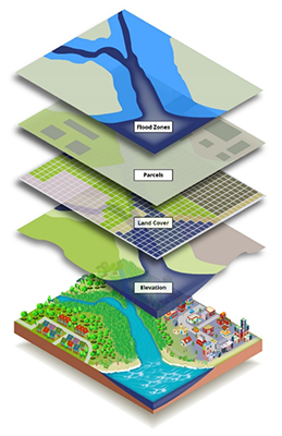
A geography information system (GIS) can be used to manage and analyse all types of spatial data. Of course, this means it is possible to track your resources and, above all, run advanced analysis to boost your productivity.
GIS has the extraordinary ability to reach each person using a common language throughout the world. These days, thousands of organisations used GIS to produce maps, make analyses, cross-match data, solve complex problems and pool data.
Comprising 15 experienced experts with wide-ranging skills, our team carries out your projects, which might be simple or complex.
GIS - A few fields of application and projects
Support for local authorities
- Cadastre of cemeteries and public roadways
- Implementing a Geoportal
- Occupation of the public domain
- Public interest data
- PICC (reference mapping of Wallonia)
Networks
- Distribution water - Water sanitation - Motorways and other roadways - Integration for distribution networks
- ArcGIS Utility Networks
Mobility
- Cycle-path networks
- Planning for roadworks
Environment
- Forestry plots
- Water protection
- Ground study
- Protection of natural spaces
Operational optimisation
- Inspection of technical equipment
- Home help
Spatial analysis
- Transformation and large-scale data processing
- Management and pooling of spatial data
Tourism
- Integration of data from cycling and walking networks
CILE
Modernisation and migration of the mapping solution to meet current and future expectations
“When I discovered how we might work together, it quickly became a real triumph. It helped us to see our business in a different light, with people who are competent, motivated and available. The availability of people at NSI was highly satisfying as well.”
Development and integration of personalised business solutions;
Integration of ArcGIS Enterprise or open-source solutions
GIS consultancy;
Modelling and optimisation of geo-data;
Implementation of the spatial data infrastructure;
Pooling resources and data access;
Web services (dissemination of spatial data, geo-processing, interoperability, etc.) ;
Development of profession-based applications on many different platforms (from office tools to mobile solutions, including enhanced web applications);
Maintenance of your applications;
Help Desk and possibility of SLA.
ArcGIS and FME expertise
Why NSI ?
Proven track record
Over fifteen years of experience in development, integration and maintenance of mapping applications in many functional domains has allowed us to set up a real skills-centre in terms of geomatics to offer our customers all the experience required to run their project properly.
A team dedicated to your project
Our team has reliable and competent professionals with vast experience (consultants, functional and product experts, data processing, ETL, architects and developers focussing on GIS Web technology, etc.), capable of taking on project responsibility, be it simple or complex.
Customer-driven
We work day-in day-out to meet your needs, making and keeping you happy. Due to its size, competence and skills, NSI allows you to get the best out of a reliable partner capable of meeting your requirements and remaining at your service throughout the project.
GIS partners and technology
Contact us ...
If you'd like more information about our solutions, please leave your contact details and we'll get in touch with you as soon as possible.